GeoloGeee Whiz DownUnder
Geology of Illinois DownUnder: Physiography, surficial sediments and Quaternary stratigraphy of Southern Illinois
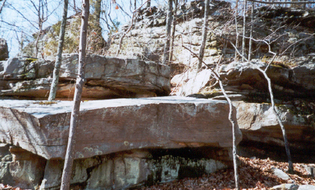
Photo by Erica Travis >>>>>>>
Intriguing rock formations and fossils reveal Southern Illinois’ dynamic and quite “checkered” geologic past. From below, volcanic, yes volcanic, and earthquake activity left areas of bedrock stacked precariously upon or leaning against bedrock. Some now suggest, a giant meteor may have paid us a visit. Comment will be withheld until further investigation supports or refutes this hypothesis. The following are well established facts. Southern Illinois is “quadrisectioned” by geologic divisions known as 1) Coastal Plain Province, to the south, 2) Central lowland Province, to the north, 3) Interior Low Plateaus Province, to the east, and 4) Ozark Plateaus Province, to the west. Present day terrain, typical of these areas, owes much of its character to above ground forces of glaciation, glacial melt, glacial dust, wind, and radical climatic changes.
Maybe difficult to imagine, extreme Southern Illinois represents the northernmost reaches of the Ancient Gulf of Mexico, known as the Mississippi Embayment. Marine fossils discovered in 1990 by Joe Devera, Illinois State Geological Survey, in a Pounds Sandstone & Shale bed on Bear Branch Creek, just north of Eddyville, mark the northernmost estuary of the ancient sea. Rippled sandstone and shale bears evidence of tidal activity. Yes, tidal pools existed in Southern Illinois. Alligator gar still haunt bottom land creeks and occasionally strike fear in an unwitting bait caster.
Plentiful are Pennsylvanian and Mississippian epoch fossils. Fossilized, stigmaria, which is the root portion of ancient, tropical scale and seal trees, is common. Stigmarian casts are found in strata which underlies Pennsylvanian coal beds. This layer is considered to be the “soil from which swamp forests began to grow.” Today, isolated pockets of remnants remain. A much smaller, but similar plant, “equisetum” graces nutrient rich, rock bottom streams and pools. You may know these peculiar, pull apart plants as “scouring rush or horsetail.” Early settlers, using these fibrous Sphenophytes as pot and pan “souring pads” had no notion they were exploiting the attributes of our only remaining descendants of a group of 50 ft. high trees, the Calamites. Tropical Southern Illinois...what a concept.
Yikes, where is all that prime ocean front property now? You know that answer. Where is all that water? Look up. Yes, its floating around in our planet’s atmosphere. A warming, expanding atmosphere “absorbed” excessive glacial melt waters, which overflowed the oceans in the first place, through the processes of evaporation and diffusion.
Southern Illinois is one of three “Unglaciated” areas in Illinois. The others are located in northwestern portions of the state. Unglaciated does not mean “unaffected” as the term may seem to indicate.
Glaciers certainly impacted all of Southern Illinois’ present-day topography. Glacial melt produced our area’s most fantastic reminders of their presence, past. Warming temperatures twice melted leviathan ice. First, about 500,000 million years ago, the Illinoisan Glacier began to melt. A more recent Wisconsian Glacier, began to melt some 75,000 years ago. Both produced flooding of colossal proportions. Torrents of water pounded and scoured Southern Illinois’ hill country until only 14,000 years before present.
One most incredible geological feature created by these natural processes is Lusk Creek Canyon in Pope County. Here one can best internalize just how powerful a substance, as soft as water, can be, given enough volume and time. Beautifully, incised sandstone canyons loom as 30 to 100 ft. high monuments to the ages.
Glaciers influenced Southern Illinois’ current terrain in other significant ways as well. Mountains of ice, crawling over thousands of square miles of rock, cracked, crumbled, and pulverized stone into pieces ranging from house sized boulders to flour sized particles.
Floodwaters then carried these particles and deposited them throughout, mostly low-lying, areas such as the Cache River Basin. These water deposited particles, collectively, are known as “Alluvium.” Cypress Swamp Wildlife Refuge, now recognized by the United Nations as one of earth’s 25 most important wetlands, supports a wealth of plant and animal species dependent on this alluvial substrate. Today, we enjoy this areas unique ecology, one born of ancient fire and ice.
Periods of drought and hurricane-like winds followed glacial retreat. Wind-borne particles blanketed the terrain in a more ubiquitous manner. Such deposits are known as “Loess”. A rugged (unglaciated) topography, with elevations ranging from 279 to 1064 feet above sea level, resulted in deposits settling to form a mosaic of soil types. Alluvial soils dominates low-lying and flat, poorly drained areas such as the aforementioned Cache River Basin. Loess, dominates well drained, hill country.
Northern reaches of extreme Southern Illinois, outline the southern extent of the Central Lowland Province. A breathtaking (literally) hike to Stoneface in Saline County, 10 miles southeast of Harrisburg provides a striking view of the contrasting interface between The Central Lowlands Province and the Interior Low Plateau Province.
Subsequently thousands of years witnessed natural succession, across Illinois’ 15 or so types of landscapes, without human interference. We have just completed a saltatory account of some 600 million years.
John Deere’s invention in 1837, the self-scouring steel-bladed plow, marked the end of Illinois’ tallgrass prairie and the beginning of southern hill country erosion. Forever changed, Illinois would become an agricultural giant and an ecological tragedy. In 150 years, all but 2,300 acres (less than 1/100th of 1%) of original prairie was destroyed. Staggering, compared to 22 million acres of prairie once flourishing with grasses, wildflowers, and abundant wildlife. And our forests...well. Have you ever hiked through a “virgin” forest?
Happily, in even less time, science has discovered the errors of our ways. Public environmental awareness is on the rise. A measure of success has been achieved in scientific, social, and political recognition of our environmental and ecological status. Premature perhaps is the following admonition. Historically speaking, humans are just now coming to terms with our need, no duty, to exercise habits conducive to the maintenance of a healthy or fit planet.
Individuals may one day awaken to realize, “hey I’m way outta shape.” This is good but... undoubtedly, the most universal misconception in the world of physical fitness is that one “gets fit.” Inappropriately parallel with this idea of “getting fit” is an often unconscious notion that reaching a certain goal weight or body composition is success. So many fall back into poor health habits because of this “unconscious” misconception. In fact, reaching the goal weight or whatever is merely arrival at the starting line to a race which must last a lifetime. Success is in the follow-through.
Likewise, many humans have identified the need for a fit planet. This is encouraging but even those at the front of this race must never forget that if and when we allow our planet to return to its most balanced state we have merely begun the race. As in a personal sense, great effort will always be required to maintain an already healthy planet.
Intimacy with planet earth and knowledge of natures ways elevates ones position on environmental issues. Social, economic, and political ramifications pale and an emotionally charged, fact based platform develops. Pure concern for the future of ones own offspring and/or future generations then becomes sufficient motivation for action.
Natural Divisions
Be Watching! Many More Links to Come!
Dinousaur Tracks? Did Dinosaurs WalkAbout Southern Illinois?
Stay Tuned!
SIUC Department of Geology ~ Harvey Henson, Jr. Community Service
Four of the Ten Units (types of quaternary deposits) in Illinois are found in the Shawnee.
Age: Pre-Illinoisan (500,000 Before Present “B.P.”)
The largest deposit is “BEDROCK” which is most prominent in an area called the Shawnee Hills. Shawnee Hills are found in southeast Jackson, south Williamson, south Saline, south Gallatin, eastern Union, all Johnson, all Pope all Hardin, northeast Pulaski and north Massac counties.
Recent & Wisconsian (75,000 years B.P. to Present)
The 2ND largest deposit is “RIVER ALLUVIUM, WIND-BLOWN SAND AND SAND & GRAVEL OUTWASH.”
This deposit borders the Mississippi & Ohio Rivers and an oscillating belt courses through the bedrock country of southern Union & Johnson counties. A southward and then northward diversion creates a “V-Shaped” section in the Alluvial belt in northern Massac and central Pope counties. This belt is continuous with the Mississippi deposit.
A separate alluvial deposit exists along the Ohio River in the southeastern half of Massac county and the extreme southern tip of Pope county’s dogleg.
The aforementioned alluvial belt demarcates the course of the Cache River and the Big Bay region which is reminiscent of the Ancient Glacial melt drainage and subsequent recession of the Mississippi Embayment, which was once the northernmost reach of the Gulf of Mexico.
Wisconsian (75,000 years B.P. to 1000 years B.P.)
The 3RD largest deposit is “WIND-BLOWN SILT (LOESS) which is more than 6 meters (20 feet) thick. This deposit borders the inland border of the Mississippi “Alluvial” deposits, found running north to northwest through west central Jackson county, north to south and southeast in central Union county, running north to southwest and including most of northern Alexander county. A large pocket of “wind-blown Silt” deposit is located in north central Pulaski county.
Wisconsian (75,000 years B.P. to 10,000 years B.P.)
The 4TH and smallest deposit is fragmented. This type of quaternary deposit is “Glacial and Slackwater Lake deposits of silt, clay, & sand.” Two deposits are found in Johnson county. One begins along the western county line at about 2/3rds to the north and runs southeast over “Bedrock” to meet the “Alluvial Belt” in the south central part of the county. The county’s second deposit runs nearly parallel to the first but is located near the east central county line. This deposit is only 1/2 the size of the western deposit.
the 3rd fragment of the “Silt, Clay and Sand” deposit runs east/west with a northward curve through central Massac county.
These Quaternary deposits contribute considerably to the rich biodiversity for which southern Illinois is finally gaining recognition.
BEDROCK:
Bedrock consist primarily of sandstone, limestone, shale and siltstone. Youngest bedrock (Carbondale formation) is found in the Eddyville Quadrangle.
Sandstone is represented by four members:
1) Wayside Sandstone (Oldest)
2) Battery Rock Sandstone
3) Drury Sandstone
4) Pounds Sandstone
NOTE: Each of the four members contain quartz & arenetic.
Limestone (Softer than Sandstone)
Kinkaid Limestone has four members, that are generally 120-160 feet thick.
1) Negli Creek (Basal) Limestone
2) Cave Hill Limestone
3) Goreville Limestone
4) Grove Church Limestone
FAULT ZONES, ANTICLINES, SYNCLINES AND MONOCLINES
Late Pre-Cambrian to Early Cambrian Rift System
NOTE: Each feature mentioned here is part of the Reelfoot Rift and Rough Creek Graben.
- Fluorspar Area Fault Complex
- Hicks Dome
- Lusk Creek Fault Zone
- McCormick Anticline
- New Burnside Anticline
- Wabash Valley Fault system
The Sparta Shelf is positioned as though it were the tail and spine of the Shawnee (Fox Forest - so-called by myself in reference to the fox-like shape of the Third Principal Meridian).
Illinois north of the Sparta shelf is characterized by generally flat, dry lake type terrain which consist of loess deposits as thick as 50 feet.
Illinois south of the shelf is one of the three areas in Illinois left relatively untouched by glacial ice. Glacial meltwaters, however, have left profound evidence of their relatively powerful sculpting forces. Dozens of sand and limestone canyons still stand as evidence of the mighty eroding force of water. In fact, bedrock is the predominant geologic feature in this area. The ravines and canyons of the Shawnee are some of the midwest’s best examples of glacial meltwater forces. Southern Illinois’ fascinating geological features are the products of millions of years of tectonic activity followed and accompanied by thousands of years of deluge by glacial meltwaters resulting from a relatively sudden onset of global warming.